

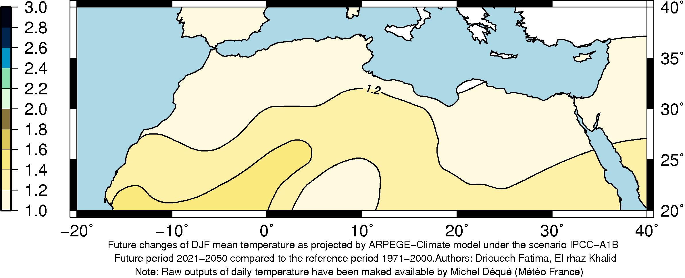
| Winter | Spring |
|---|---|
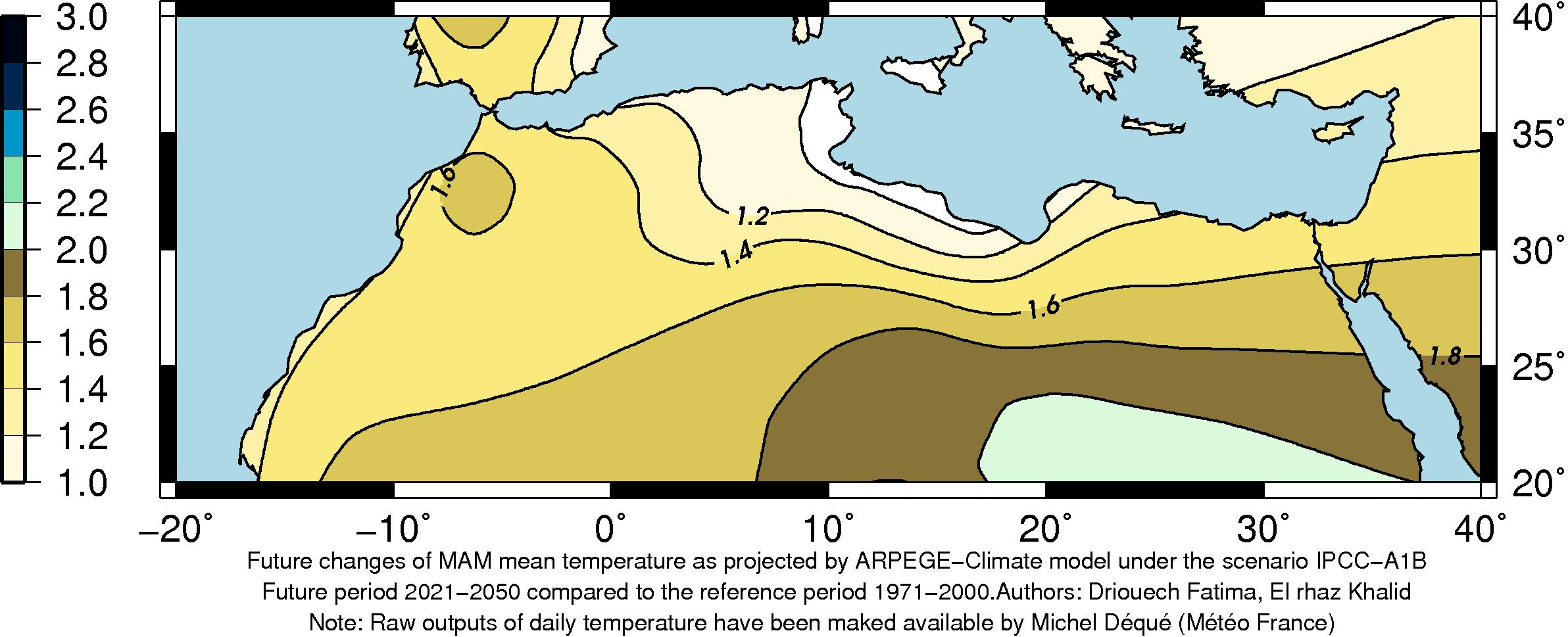
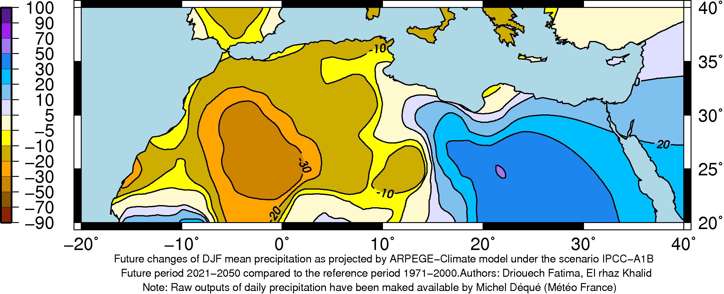 |
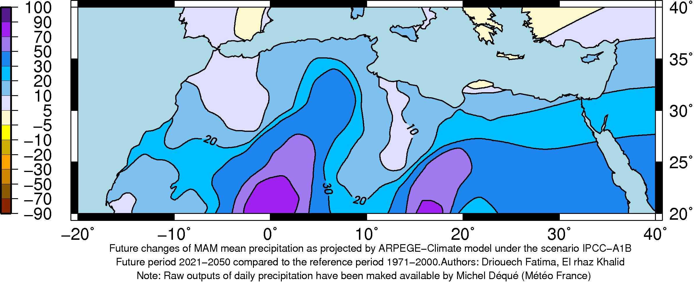 |
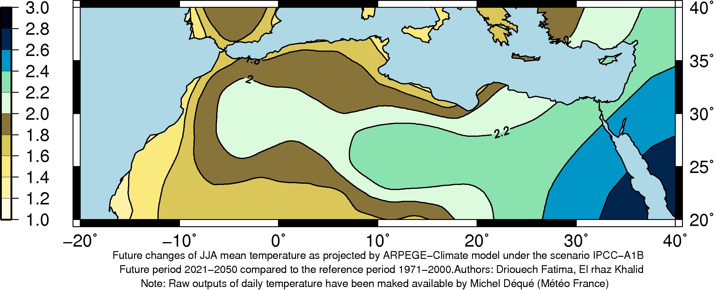
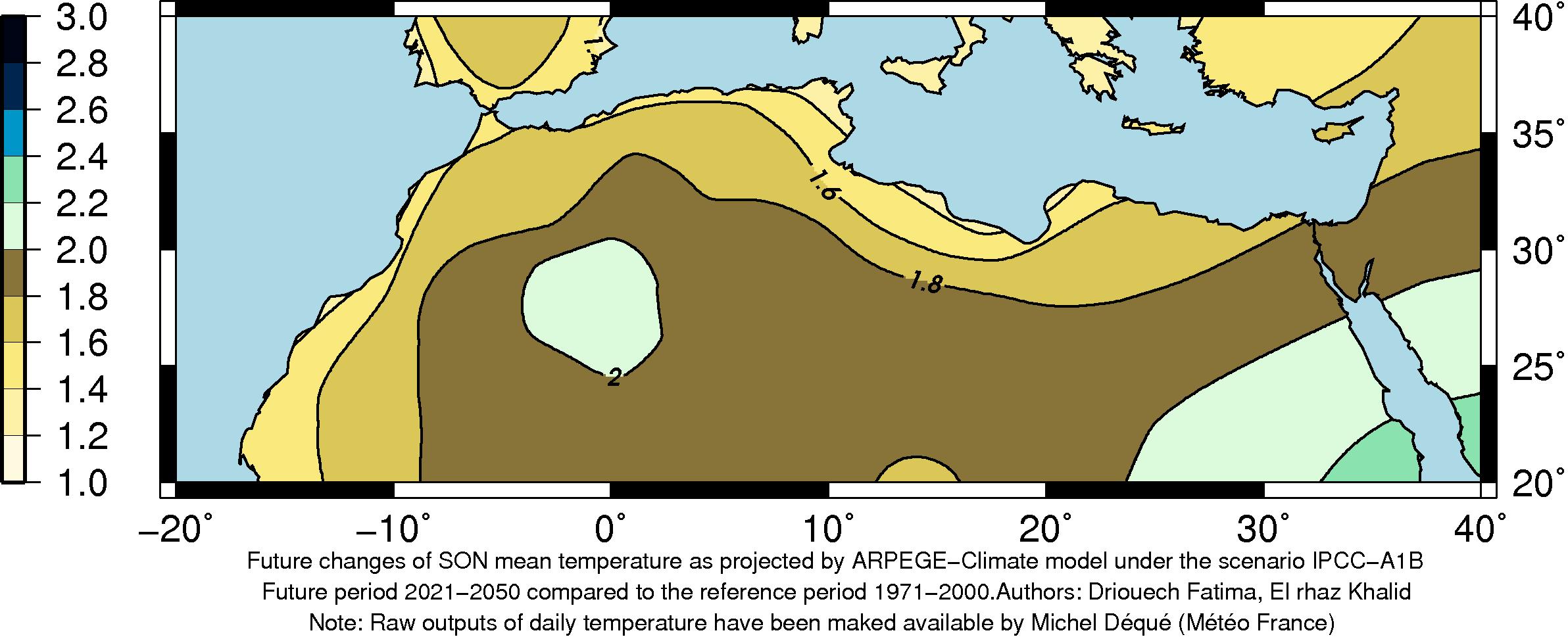
| Summer | Autumn |
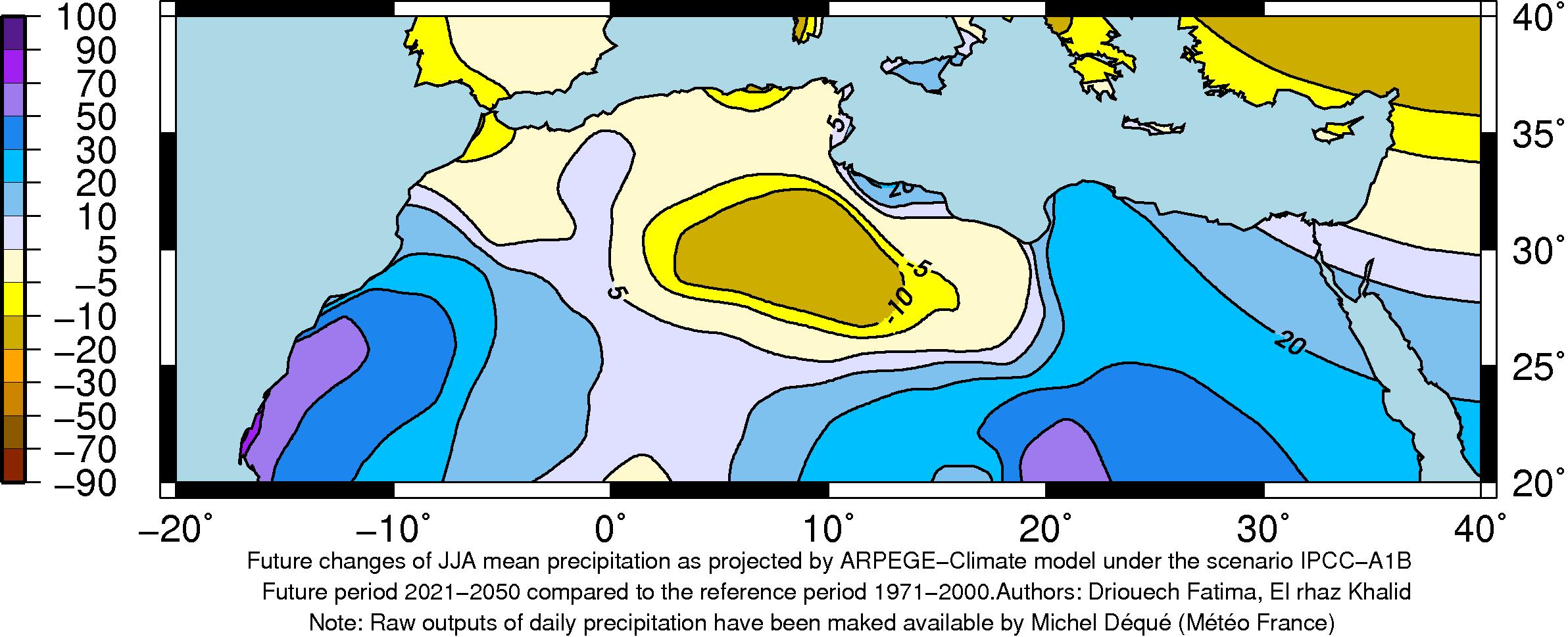 |
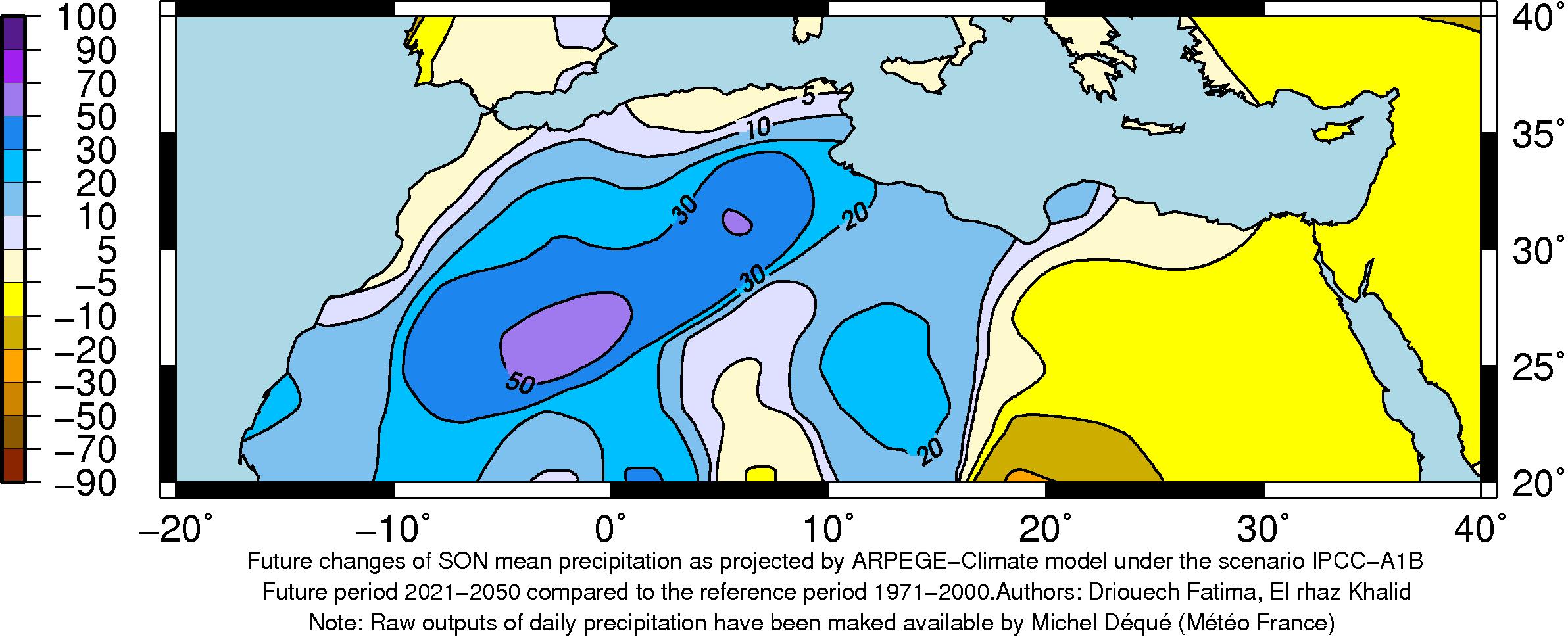 |
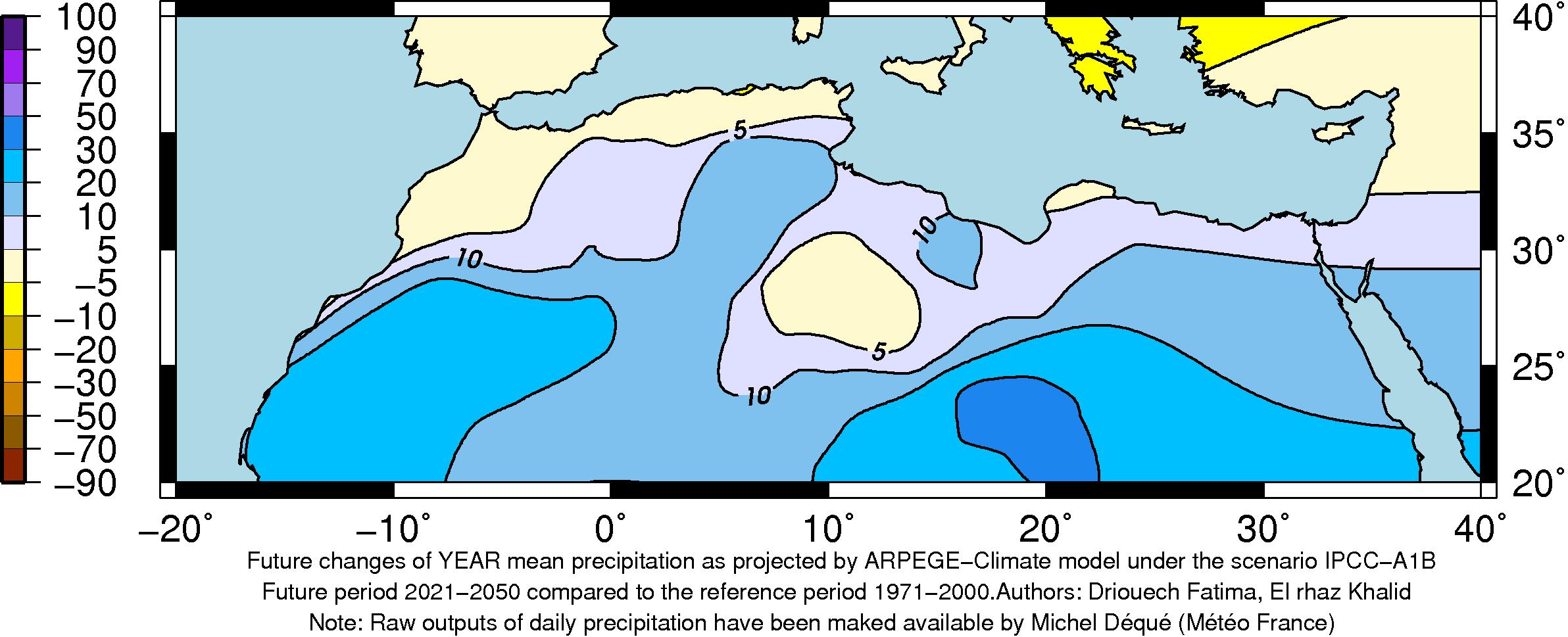
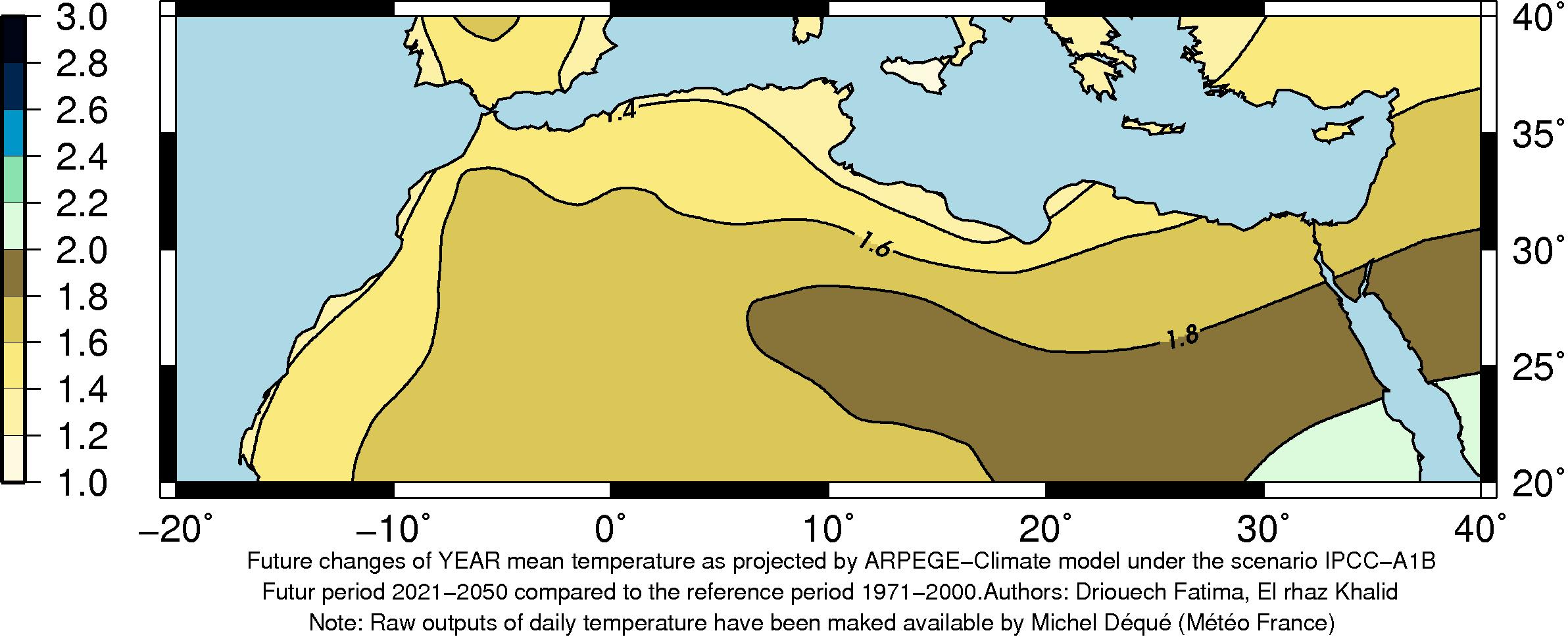
| Annual | |
 |
Climate scenarios
| Winter | Spring |
|---|---|
 |
 |
| Summer | Autumn |
 |
 |
| Annual | |
 |
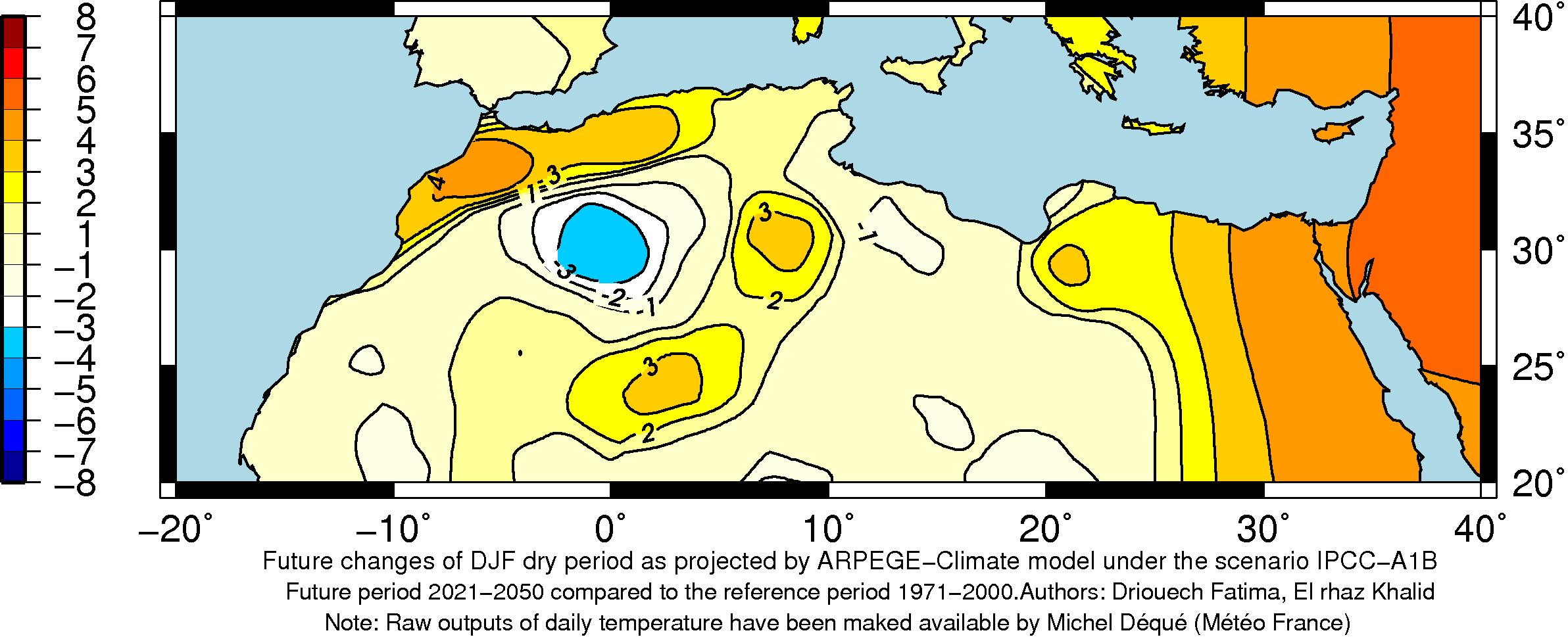
| Winter |
|---|
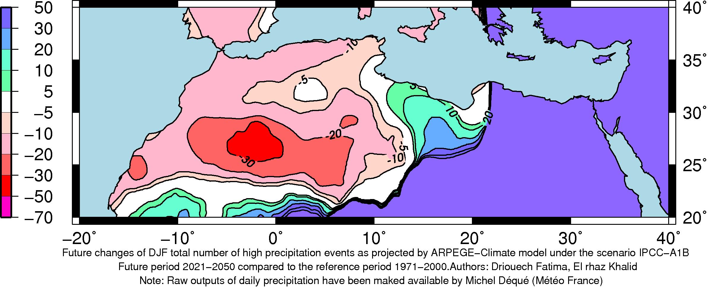 |
| Winter |
|---|
 |
Description
Climate indices :
Pecipitation Average (pav):
Precipitation average for a given season (or year) is equal to the average of daily precipitation calculated over of wet days of this season (or year). A wet day is a day with daily precipitation above 0.5 mm.
Temperature Average (tav):
Temperature average for a given season (or year) is equal to the average of daily mean temperature calculated over the total number of days of this season (or year).
Maximum number of consecutive dry days (pxcdd):
The maximum number of consecutive dry days for a given season (or year) is the maximum number of consecutive days with cumulative rainfall below 0.5mm.
Number of high precipitation events (pnl90):
It is the total number of days with cumulative precipitation above the 90th percentile calculated over the wet days of the reference period.
Description of model used (ARPEGE-CLIMATE version 4):
The numerical model ARPEGE is a spectral general circulation model. Historically, it has been developed for "operational numerical weather forecast" by Météo-France in collaboration with ECMWF (Reading, U.K.). Its climate version (ARPEGE-Climate) has been developed in the 90s (Déqué et al., 1994). ARPEGE-Climate became the atmosphere part of the CNRM model "earth modelling system" which couples different components of the climate system (atmosphere, ocean, land-surface, sea ice).
The ARPEGE grid can be tilted and stretched by changing the position of the pole and increasing the horizontal resolution over an area of interest. This zoom ability allows regional climate studies with ARPEGE -Climate (Déqué and Piedelievre, 1995; Gibelin and Déqué, 2003).
The version used for the scenarios is Version 4 with a vertical resolution based on 31 levels located between the surface and 10 hPa with only four pressure levels above 80 hPa. It uses cycle 24 of ARPEGE/IFS (the numerical software developed jointly by ECMWF and the French Meteorological service (Météo-France) for short- and medium-range weather forecasting).It uses semi-lagrangian advection and a two time-level discretization. Vertical discretization uses hybrid coordinates (Simmons and Burridge 1981).The time step is 30 min.The variable resolution configuration has a T106 spectral truncation. The pole of stretching is at (28ºN, 08ºW, i.e. approximately at the centre of Morocco) and the stretching factor is 3. The grid has 120 pseudo-latitudes and 240 pseudo-longitudes (with a reduction near the pseudo-poles to maintain isotropy), so, the maximum horizontal resolution is (about 0.5º). The convection scheme is the same of (Bougeault 1985) with only minor changes.
The Morcrette (1990) scheme is used to calculate the radiation, which includes the effect of four greenhouse gases (CO2, CH4, N2O and CFC) in addition to water vapour and ozone, and of five aerosol types (land, sea, urban, esert and sulfate) in addition to background aerosols. Indirect effects of sulfate aerosols are parametrized by an empirical function for the cloud drop effective radius. The prescribed aerosols follow an annual cycle (Tegen et al., 1997). The cloud-precipitation-vertical diffusion scheme uses the statistical approach of Ricard and Royer(1993). The vertical diffusion in the planetary boundary layer (PBL) uses a parabolic profile for the mixing length allowing a more efficient diffusion in the upper part of the PBL. The ISBA soil vegetation scheme (Douville et al. 2000) has been used. Temperatures at larger depths are not relaxed towards climatology. Instead, a four-layer heat diffusion scheme is used. The soil hydrology parameterization uses four reservoirs: a canopy interception reservoir, a snow reservoir, a shallow surface reservoir and a root layer reservoir. The root reservoir includes a liquid and a solid reservoir. Representation of orographic gravity wave drag take account mountain blocking and the lift effect (Lott and Miller 1997; Lott 1999). Version 4 has been evaluated by Driouech et al. (2009) and have been used for evaluation future change over Morocco by Driouech et al. (2010).
References
Bougeault P (1985) A simple parametrization of the large-scal effects of cumulus convection. MonWeather Rev 113: 2108-2121.
Déqué M., Dreveton C., Braun A., Cariolle D. (1994) : The ARPEGE-IFS atmosphere model: a contribution to the French community climate modelling. Climate Dynamics 10:249-266 Déqué M. and Piedelievre J.-P. (1995) : High-Resolution climate simulation over Europe. Climate Dynamics 11:321-339
Douville H, Chauvin F, Royer JF, Salas-Melia D, Tyteca S (2002) Sensitivity of the hydrological cycle to increasing
amounts of greenhouse gases and aerosols. Clim Dyn (in press)
Driouech F., Déqué M., Mokssit A. (2009) Numerical simulation of the probability distribution function of
precipitation over Morocco, Clim. Dyn., 32, 1055-1063.
DOI:10.1007/s00382-008-04310-6.
Driouech F., Déqué M., Sánchez-GÓmez E. (2010) Weather regimes-Moroccan precipitation link a regional
climate change simulation. Glob Planet Change.
DOI:10.1016/j.gloplacha.2010.03.004.
Lott F, Miller MJ (1997) A new subgrid-scale orographic drag parametrization: its formulation and testing. QJR Meteorol Soc 123:101-127.
Gibelin A.-L. and Déqué M. (2003) : Anthropogenic climate change over the Mediterranean region simulated by a global variable resolution model. Climate Dynamics 20:327-339
Morcrette JJ (1990) Impact of changes to the radiation transfer parametrizations plus cloud optical properties in the ECMWF model. Mon Weather Rev 118:847-873.
Ricard JL, Royer JF (1993) A statistical cloud scheme for use in an AGCM. Ann Geophysicae 11:1095-1115.
Simmons AJ, Burridge DM (1981) An energy and angular momentum conserving vertical difference scheme and hybrid coordinates.
Mon Weather Rev 109:758-766.
Tegen I., Hollrig P., Chin M., Fung I., Jacob D., Penner J., 1997: Contribution of differen aerosol species to the global aerosol extinction optical thickness: estimates from model results. J Geophys Res 102:23895-23915. doi:10.1029/97JD01864.